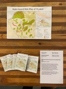
This art piece is designed to visually communicate the cascading risks to the people of Musikot Municipality, Rukum West, Nepal. It serves as a handy tool—a pocket book—that can be adopted to convey the risks associated with various hazards that the community may encounter, such as earthquakes and landslides.
 The pocket book identifies potentially vulnerable locations, critical facilities, and road networks. It also indicates the level of risk associated with each hazard. This detailed mapping allows residents to understand the specific threats they face in their locality. Additionally, it provides preparedness information to help the community effectively respond to these hazards.
Through clear visuals and concise information, this tool aims to enhance the community’s awareness and readiness, ultimately contributing to the safety and resilience of Musikot Municipality.


